martes, 13 de septiembre de 2011

cityGML patch for windows

Hi again!

Here it is the patch for windows. As we said in the previous post the implementation is based on the library libcitygml[1]. This open source project is still in development and we'd like to thank to Joachim Pouderoux (the main developer) for his kindly help. 

The work is in progress, but we think it is a good moment to let the community to test this new feature. The patch is now available for linux and windows. The instructions to install it in windows are the following -also available in a README.txt file- (see [2] to install in linux):
  1. Download the file for your Operating System from[3]. 
  2. Make sure you have installed gvSIG-1.11[4] and the final release of 3D extension[5].   
  3. Unzip the patch into a temporal directory.
  4. Copy bin directory into your gvSIG installation directory,  usually located at: C:\Program Files\gvSIG_1.X.X\
  5. 3) Copy the content of Java directory into your current Java VM directory: 
    C:\Program Files\Java\jre1.6.0.X\
  6. Run gvSIG 1.11 and follow the videotutorial[2]
Important note: If you have different Java VM installed in your system 
you can check if the folder jre1.X.X/bin has a subfolder called osgPlugins-2.8.3 
to check the correct version (the one used by gvSIG and the 3D extension). 
In addition, some windows systems need administrator privileges to overwrite this files.

[1]http://code.google.com/p/libcitygml/
[2]http://gvsig3d.blogspot.com/2011/09/patch-to-load-citygml-models-in-gvsig.html
[3]http://www2.ai2.upv.es/difusion/gvsig3d/citygml_patch/
[4]http://www.gvsig.org/web/projects/gvsig-desktop/official/gvsig-1.11/downloads
[5]http://www.gvsig.org/web/projects/gvsig-desktop/official/gvsig-1.10/extensiones-gvsig-1.10/extension-3d/downloads

viernes, 9 de septiembre de 2011

Patch to load cityGML models in gvSIG 1.11 + 3D extension

Hi community!

We are working again after a great holydays. This time we want to share with you our advances in the scope of the Project "España Virtual". For this reason we have done a backport for gvSIG 1.11 of a new feature we are working on: to load cityGML models.

The implementation is based on the library libcitygml[1]. This open source project is still in development and we'd like to thank to Joachim Pouderoux (the main developer) for his kindly help. 

The work is in progress, but we think it is a good moment to let the community to test this new feature. The patch is only available for linux (we expect to upload the patch for windows in a few days) and the instructions to install it are very simple:
  1. Download the file for your Operating System from[2]. 
  2. Make sure you have installed gvSIG-1.11[3] and the final release of 3D extension[4].  
  3. Extract the compressed file in the folder you installed gvSIG-1.11, overwriting the folders bin and libs.
  4. Run gvSIG 1.11 and follow the next video tutorial! :)


Important note: cityGML files must be renamed as .citygml, otherwise the osg loader won't be able to load the models.

[1]http://code.google.com/p/libcitygml/
[2]http://www2.ai2.upv.es/difusion/gvsig3d/citygml_patch/
[3]http://www.gvsig.org/web/projects/gvsig-desktop/official/gvsig-1.11/downloads
[4]http://www.gvsig.org/web/projects/gvsig-desktop/official/gvsig-1.10/extensiones-gvsig-1.10/extension-3d/downloads

viernes, 29 de julio de 2011

WIP: 3D extension on gvSIG 2.0

Hi all!

Just before the gvSIG 3D team goes away on vacations, we'd like to show you a sample of one line of work that has been in development for the last few months. Since the release of gvSIG 2.0 is getting closer, we decided to start the process of adapting gvSIG 3D to this new version in the scope of the España Virtual project.

As some of you may know, gvSIG 2.0 is not just an iteration of the 1.x branch, therefore changes have been made to the core of the application that doesn't make the task of porting our extension a trivial job.
In this post we would like to make a little summary of the tasks that have been already finished, and those that are still in development.

Finished tasks:
  • Adapted the building system and dependencies.
  • Changed the projects architecture to match the gvSIG 2.0 requirements.
  • Document View3D available from the Project Manager. Creates and customizes spherical and flat planet views.
  • Loading of raster and rasterized vectorial layers.
  • Integration of the gvSIG 3D tools. Navigation modes, stereo and fullscreen visualization, etc.
In progress:
  • Adapt the extension to work with osgVP 3.0.
  • Use the cache system of the new raster libraries.
  • Analyze and integrate the new symbology framework from osgVP and gvSIG.
  • Modify the persistence mechanism to match the new requirements.
  • Integrate the load and edition of OSG layers.


Finally, in the next video, you can see gvSIG 3D running on top of the latest build (2030) of gvSIG 2.0.


Keep in mind that the status of the project is still of early alpha, therefore there isn't a binary distribution to download yet.

miércoles, 6 de julio de 2011

Coming soon: PostGIS 3D!!

Hi all,

We are really happy to announce this new feature. A part form being a nice improvement it has something special... it comes from the community!

The author of the patch is Jose Carlos Martinez-LLario from DICGF at UPV. He is very skilled in spatial database development, in fact he owns a very promising project called JASPA. We have to mention Fran Peñarrubia and Nicklas Aven, they helped too in testing and integration of the patch.

So...Thank you very much guys!

The patch is already commited in the trunk of gvSIG 1.1x and it will be available in gvSIG 1.12 version. This patch does not change anything in gvSIG 3D, the changes are applied to the core of gvSIG so the same version of 3D extension (codename "BladeRunner") should work with postGIS 3D.

Next video is a demo of postGIS 3D running in gvSIG 3D. We'll do some tutorial when gvSIG 1.12 becomes available. 

miércoles, 29 de junio de 2011

OpenSceneGraph-3.0.0 released!

Hi all!

A new version of OpenSceneGraph (OSG) has been released. OSG is the standard scenegraph for OpenGL Applications and we are using it extensively in our core library OSGVirtualPlanets (osgVP). We are proud to be contributors of OSG, and our last contribution was to add Android support to the library. Next releases of OSGVirtualPlanets will be built against OSG 3.0.0.

From here we'd like to thank the work done by the whole OSG community and specially to Robert Osfield, the leader of the library. 
 
FYI this is the OSG 3.0 Press Release: 

OpenSceneGraph 3.0 release adds support OpenGL ES 1.1, OpenGL ES 2.0, OpenGL 3.x to 4.0, support for Android and IOS platforms and much more

PERTHSHIRE, Scotland - 28th June 2011 - OpenSceneGraph Professional Services announces the release of OpenSceneGraph 3.0, the industry's leading open-source scene graph technology, designed to accelerate application development and improve 3D graphics performance. OpenSceneGraph 3.0 written entirely in Standard C++ and built upon OpenGL, offers developers working in the visual simulation, game development, virtual reality, scientific visualization and modeling markets - a real-time visualization tool which eclipses commercial scene graph toolkits in functionality, stability and performance. OpenSceneGraph 3.0 runs on all Microsoft Windows platforms, Apple OS/X, IOS, GNU/Linux, Android, IRIX, Solaris, HP-UX, AIX and FreeBSD operating systems.

Open-source development delivers industry-leading features and performance

The OpenSceneGraph 3.0 release is the culmination of 12 years of work by the lead developers and the open-source community that has grown up around the project. The real-time graphics industry and academia embraced it from the very beginning, deploying it in real-world applications, and actively participating in its development, testing and refinement. The end result is a high-quality library with a feature set relevant to application developers' needs.

Updates include:

  • OpenGL ES 1.1, and OpenGL ES 2.0 support
  • OpenGL 3.x and 4.x support along with associated OpenGL extensions
  • Support for Android on tablets and phones
  • Support for IOS on tablets and phones (end users applications have already been accepted on the App Store)
  • New extensible serializers that provide new .osgb binary, .osgt ascii and .osgx xml file native formats
  • New generalized serializable metadata architecture
  • New osgQt library that makes it straight forward to integrate OpenSceneGraph with Qt
  • new FBX plugin
  • Improvements to osgVolume enabling high quality race traced volume rendering
  • Improvements to osgManipulator making it more flexible
  • Support for Cocoa and 64bit OSX build
  • Improved thread safety and efficiency of database paging
  • New Texture and buffer object pools for efficiently managing GL object resources

Downloads and Licensing

OpenSceneGraph is open-source, so full source code is provided, and can be copied, modified and used free of charge for commercial and non-commercial use. Access to the source allows end users greater flexibility in how they develop, debug and deploy their applications. They gain productivity and freedom by being able to leverage the tool chain in accordance with their own release cycles. Downloads of binaries and source can be found in the Downloads section of the openscenegraph.org website.
OpenSceneGraph is released under the OpenSceneGraph Public License, which is based on the Lesser GNU Public License (LGPL), permitting the software to be used free of charge across the full spectrum of commercial and open-source applications. Furthermore, it allows both static and dynamic linking of the OpenSceneGraph libraries without restricting the licensing of the user's software.

OpenSceneGraph Books now available

The new book dedicated to the OpenSceneGraph 3.0 is now available https://www.packtpub.com/openscenegraph-3-0-beginners-guide/book.

Professional support and services

OpenSceneGraph project is backed up with professional services by OpenSceneGraph Professional Services, based in Scotland, and Skew-Matrix and AlphaPixel both based in the USA, and a range of Contractors from around the world. Services available include:
  • Confidential Professional Support
  • Bespoke development
  • Consultancy
  • Training

Community support and contribution

The diverse and growing community of over 5000 developers is centred around the public osg-users mailing list/forum, where members discuss how best to use OpenSceneGraph, provide mutual support, and coordinate development of new features and bug fixes. Members of this community come from many different countries with backgrounds ranging from some of the world's largest aerospace companies, game companies, and visual simulation specialists to university researchers, students and hobbyists.
The OpenSceneGraph project owes a great deal to the community for its development and support, in particular we wish to thank the 464 individuals from around the world that have directly contributed to the development and refinement of the OpenSceneGraph code base.

viernes, 3 de junio de 2011

Some developments using gvSIG 3D in "España Virtual"

English

There are several I+D teams working with gvSIG 3D in the scope of "España Virtual" project, a CENIT project supported by CDTI[1].  Their works are very interesting, and we were able to see some of them at last EV workshop. We asked them for permission to show what are they doing with gvSIG 3D. So we would like to thank to the following enterprises: Deimos[2], Indra[3] and Telefónica I+D[4]. In addition we'd like to thank to the following institutions and universities: Polytechnical University of Madrid(UPM)[5], the Institute of applied computing and community code(iac3)[6] from the University of the Balearic Islands.

The developments of this people are quite technical so forgive me in the case anything is not correct.

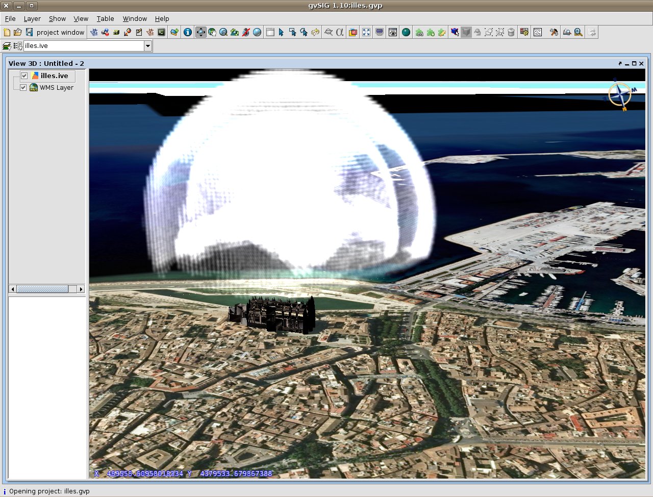
The first two images (from iac3) we show are related to 3D geovisualization of physicall phenomenon in a given time. We hope we can see this effects in 4D in the near future! 

Español

Hay varios equipos utilizando gvSIG 3D en el ámbito del proyecto España Virtual, un proyecto CENIT iniciativa del CDTI[1]. Sus trabajos son muy interesantes, y pudimos ver algunos de ellos el el último workshop de EV. Les hemos pedido permiso para enseñar en este blog lo que están haciendo con gvSIG 3D. Así que queremos agradecer a las empresas Deimos[2], Indra[3], y Telefónica I+D[4], y también a la Universidad Politécnica de Madrid(UPM)[5], al Institute of applied computing and community code (iac3)[6] de la Universitat de les Illes Balears que nos permitan mostrar estas imágenes.

Estos trabajos son muy técnicos, así que pido disculpas por adelantado si algo de lo escrito no es correcto.

Las primeras dos imágenes (cedidas por iac3) tienen que ver con la geovisualización tridimensional de fenómenos físicos. Esperamos poder ver estos efectos en 4D en un futuro cercano!


In the other hand Indra and UPM are working on building visualization and 3D visualization of athmospheric patterns related to air quality. They gave us this images. Every single 3D data is represented by a sphere, which color depends on the value of the data. 

Por otro lado Indra y la UPM están trabajando en la representación tridimensional de edificios y la visualización de datos 3D producidos por modelos atmosféricos y de calidad del aire. En este caso cada dato 3D viene representado por una esfera, cuyo color varia dependiendo del valor del dato. Nos han dado permiso para mostrar estas imágenes:


[1]http://www.cdti.es
[2]http://www.deimos-space.com
[3]http://www.indracompany.com/
[4]http://www.tid.es/
[5]http://www.upm.es/
[6]http://www.iac3.eu/

sábado, 14 de mayo de 2011

gvSIG 3D Team at "España Virtual" Workshop

English

This week we have been very busy attending to the "España Virtual" Workshop[1]. As many of you know this CENIT project supported by CDTI[2] and leaded by Deimos-Space[3], aims to push the state of the art of geomatic science in Spain. In the scope of this project we are developing hard in several lines of work. In this post you will be able to see a few videos of some of them.
  • Advanced Symbology: We added new render techniques to the osgVirtualPlanets library[4], the core of gvSIG 3D. These techniques let us to render new symbols with a quite good frame rate. In this video we show point sprites, particle systems and instanced rendering. We hope we can integrate these functionalities soon in gvSIG 3D. 
  • Multiresolution of vectorial data: One of the problems we have in the current version of gvSIG 3D is rendering big amount of vectorial data. Is a must to apply multiresolution techniques in order to avoid RAM memory problems and low frame rates.  This video shows a quite popular spatialization algorithm called Octree.  It could be very useful to render regular massive vectorial data, for example Lidar data.
  • Collaboration with a friend project, WebGLEarth[5] : This project enables exploration, zooming and “playing” with the globe in any web browser on any platform supporting webGL (like chrome 9[6] or firefox 4[7]). We are collaborating with them and we have implemented zoom and pan controls, and camera throwing. It is a very promising project.

Español

Esta semana hemos estado en el workshop del proyecto "España Virtual"[1]. Como muchos de vosotros sabeis, este proyecto CENIT iniciativa del CDTI[2] y liderado por Deimos-Space[3] pretende avanzar el estado del arte en el campo de la geomática en España. En el ámbito de este proyecto estamos trabajando duro en varias líneas. En este post podreis ver videos de algunas de ellas.
  • Simbología avanzada: Estamos trabajando en añadir nuevas técnicas de visualización en la librería osgVirtualPlanets[4], el núcleo de gvSIG 3D. Estas técnicas nos permitirán mejorar el tiempo de dibujado y añadir nuevos tipos de símbolos. En este video se muestran point sprites, sistemas de partículas e instanciación de geometría. Esperamos poder integrar estas funcionalidades pronto en gvSIG 3D. 
  • Multirresolución de datos vectoriales: uno de los problemas que tenemos en la actual versión de gvSIG 3D es visualizar grandes cantidades de información vectorial. Se deben aplicar algoritmos multirresolución para evitar problemas de visualización y memoria. En este video se muestra una técnica de espacialización de geometría bastante conocida, el Octree. Puede ser muy útil a la hora de representar cantidades masivas de datos vectoriales regulares, como por ejemplo los datos Lidar.
  • Colaboración con un proyecto amigo, WebGLEarth[5]: Este proyecto permite la visualización e interacción con un globo virtual en cualquier navegador y plataforma que soporte webGL (como chrome 9[6] o Firefox 4[7]). Nuestra colaboración hasta el momento ha consistido en la implementación de los controles de movimiento y el lanzamiento de cámara.


[1]http://www.españavirtual.org
[2]http://www.cdti.es
[3]http://www.deimos-space.com
[4]http://forge.osor.eu/projects/osgvp
[5]http://www.webglearth.org
[6]http://google.com/chrome
[7]http://www.mozilla.com/firefox/fx/